
What is ESTPOS?
ESTPOS is Estonia's national GNSS reference station network, managed by the Land and Spatial Development Board. This system consists of stationary receivers, or reference stations, which continuously collect satellite data. ESTPOS enables the provision of high-precision positioning services, allowing users to determine their location with centimeter accuracy.
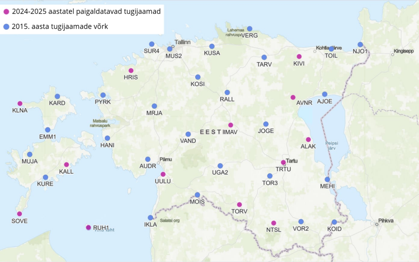
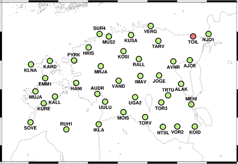
However, the reliable operation of ESTPOS is heavily dependent on the quality of GNSS signals. Figure 1 shows the ESTPOS network diagram as of April 2025.
What is GNSS signal interference?
GNSS relies on information contained in space-based radio signals, but these radio signals are so weak near the Earth's surface that they can easily be disrupted by both natural and man-made interference. Signal interference refers to a situation where a device's ability to receive or process satellite signals is impaired.
There are several types of interference:
Natural interference – solar storms (auroras), large fluctuations in air humidity, signal reflection from buildings or water surfaces.
Unintentional interference – caused by devices that are not intended to affect the GNSS signal, but do so nonetheless. Electromagnetic noise from construction equipment, radio transmitters, or power lines. Faulty GNSS devices or antennas and frequency overlap with other radio communication sources.
Intentional interference – This is intended to deliberately disrupt the reception of GNSS signals. It is divided into two types:
- Jamming
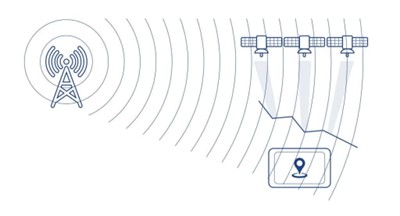
Signal jamming is the weakening of the service with generated noise so that the GNSS receiver can no longer distinguish the satellite signal (Figure 2).
2. Spoofing
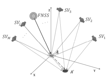
Signal spoofing attempts to force the receiver to display a false location or time (Figure 3).
ESTPOS and disturbances
The first objective of the master's thesis was to identify GNSS signal disturbances in ESTPOS reference station data and data streams. To this end, various outputs were compiled from the reference station data streams: satellite sky map, signal quality graphs, and real-time graphs. These graphs allow for a visual assessment of signal quality and the identification of possible interference in time and space. The graphs can be viewed on the Land and Spatial Development Board's geoportal: GNSS reference station graphs | Geoportal | Land and Spatial Development Board
Although numerous graphs have been compiled on the signal quality of reference stations, the most clear and informative graphs for assessing signal quality are those based on the number of satellites and signal-to-noise ratio (SNR) values. These indicators make it possible to identify potential interference and the overall stability of signal reception.
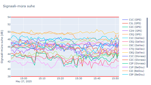
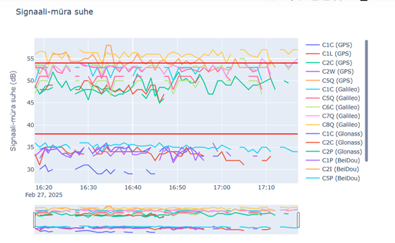
Figure 4 shows a graph of the signal-to-noise ratio in a normal situation, while Figure 5 illustrates a situation where signal interference has occurred. The SNR graphs also show error limits, which indicate the presence of signal interference, i.e., when the signal exceeds or falls below the error limits. In addition, the data discontinuity visible in Figure 5 also indicates the presence of interference, as it means a temporary signal loss or data stream interruption.
A real-time map was also created from the real-time data (Figure 6). The real-time map has four statuses: green, yellow, red, and black, where the status is determined by the SNR value or the absence of data. Interference can be easily detected by a low SNR value, which indicates a very weak signal. Thanks to this, we have discovered that interference is mainly present in Eastern Estonia.
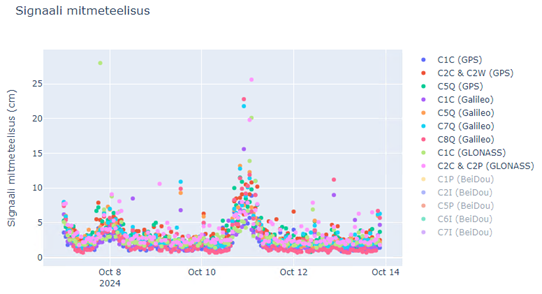
In addition, ESTPOS reference station data also detected natural disturbances caused by high solar activity, as we are currently at the peak of the solar activity cycle. This primarily manifested itself in a deterioration in the quality of the real-time kinematic (RTK) network correction, resulting in an increase in location determination error of up to 5 centimeters. An increase in signal multipath was also observed during the peak of the aurora borealis – the signal path lengthened by up to 25 cm at most, but by an average of about 10 cm.
Summary
Analysis of base station data allows potential interference to be detected. ESTPOS primarily detects intentional interference in the form of signal jamming, as the coordinates of base stations are fixed – therefore, falsification cannot be detected through normal location anomalies, as would be the case with a mobile receiver.
Take a closer look at how mitigation methods for signal jamming were tested and how signal interference occurs in Estonian airspace: https://digikogu.taltech.ee/en/Item/f6f0d522-f19f-4b55-b09f-5128e8ff5258
Author: Berit Järv, Chief Specialist, Geodesy and Aerial Surveying Department, Land and Spatial Development Board
Loomise kuupäev: 14.11.2025
