
The history of Estonian maps has evolved through various political systems to the present day – from ancient and medieval descriptions, through the Swedish era, the Russian and Baltic German periods, the first Republic of Estonia, the Soviet occupation, to the re-independence of Estonia and the present day.
How old is the map of Estonia?
It is difficult to give a precise answer to this question. Until the 17th century, maps of the Estonian area were made elsewhere – at the beginning of the 16th century, information about Northern Europe was mainly based on ancient and medieval descriptions, and this region was depicted on few maps of that time.
The first more or less accurate map of Northern Europe, Carta marina, which also shows the borders of Estonia, the larger islands, the Gulf of Riga, and a total of 35 place names in Estonia, was compiled in 1539 by the Swedish scholar Olaus Magnus.
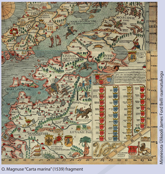
It is safe to say that since then, things have only become more accurate, and a lot of historical map material is also available in the Land and Spatial Development Board's (MaRu) historical map application.
When did people start putting data about Estonia on maps?
The beginning of Estonian national cartography is considered to be Count Mellin's "Atlas of Livonia," published between 1798 and 1810, which consisted of a general map and 14 district maps, 10 of which were of the Estonian area. Mellini's Atlas of Livonia is also available in the Land and Spatial Development Board X-GIS application and ready for research.
It must be said that such impressive drawings and details are unfortunately not found on today's Land and Spatial Development Board maps. However, it is possible to compare the map from that time with today's. Using the screen divider (two opposite arrows/triangles) on the right side of the map application, you can open two maps from different eras and then move the slider in the middle of the screen from right to left to compare how the maps differ from each other and how, for example, the coastline has changed. Or draw conclusions about the accuracy of the mapping at that time.
The animation illustrates how the Tallinn area on the map of that time differs from the current base map. At the same time, it should be noted that a large part of the Estonian coastline is mapped in great detail and is quite similar to today's map.
How did the map of Estonia develop?
In the second half of the 19th century, during the Russian and Baltic German era, even before the Republic of Estonia, three-, two- and one-verst maps were published in succession, the latter of which became the main tactical map for the Russian army in Estonia and elsewhere. It was also used in the Estonian War of Independence, after the war in the Estonian Defense Forces, and in the first years of independence for land surveying.
The map texts have been changed to Russian, and there is no longer any decorative element like that found in the Livonian atlas.
With independence, the Republic of Estonia began to produce its own maps between 1918 and 1940. At that time, the first Estonian-language map of Estonia (wall map) (1:420,000) was published. In the following years, various topographic maps, overview maps of neighboring countries, hiking maps, school wall maps, school atlases, geography textbooks with maps, city plans for almost all cities, road maps, railway maps, sea maps, elevation maps, and even a schematic cadastral map, some pages of which were never published due to the occupations.
Estonian cartography had developed to a level comparable to that of European countries. The number of original map publications in the period 1918–1940 is estimated to be at least 600, which is an average of 28 map publications per year.
The Land and Spatial Development Board map application contains several topographic maps from this period – 25T, 50T, and 200T – as well as city plans. Below are examples of the style of maps from the first republic.
This was followed by the Soviet occupation, and the development of Estonian cartography came to a halt. All cartographic and geodetic materials and archives of the Estonian Defense Forces were taken away from Estonia, and maps began to be collected and destroyed. The compilation, publication, and printing of maps was strictly centralized in the Soviet Union; maps were first compiled in Russian and could then be published in Estonian as a second edition. The basis for maps published from the 1960s onwards was distorted. The maps were lacking in information because the scale was small and much of the data was classified.
Soviet-era maps are also represented in the Land and Spatial Development Board map application. In addition to the option of splitting the screen in half, it is possible to play with different map layers by adding them and changing their transparency. To do this, use the My Layers function in the left corner.
The end of the 1980s and the restoration of independence brought new winds of change to cartography. Due to the changed circumstances, the rules for compiling, publishing, and using maps began to be relaxed. Secrecy regulations began to be ignored, and the first small local map production companies were established.
In 1992, all topographic maps, geodetic and gravimetric data, except for materials belonging to the defense forces, were declared unrestricted for use (Riigi Teataja 1992, 6, 89).
In 1990, a year before Estonia regained its independence, the Land Board was established, one of whose primary tasks was to compile and distribute national maps.
In 1991, a basic mapping project was developed and approved. From the outset, the source data for mapping has been aerial photographs, fieldwork materials, existing cartographic and statistical data.
In the early years of the project, from 1991 to 1995, maps were produced manually, without the use of computers. Digital production of the base map began in 1996. Since 1997, the entire base map production process has been digital. The digital data of the base map was used as the basis for creating the Estonian Topographic Database (ETAK). The first base map based on ETAK data was generated from a database extract as of February 2, 2009 (source: Land and Spatial Development Board).
Where are we now?
The Land Board has now become the Land and Spatial Development Board, where mapping and maps continue to be of great and growing importance from the state's point of view. While the work was initially carried out by private companies through public tenders, the entire production process, from aerial photography to the base map, is now in the hands of the Land and Spatial Development Board itself.
High-quality map data is a prerequisite for the performance of many state functions. Virtually all land management and assessment activities are based on the map data created by the Land and Spatial Development Board, which is used to establish restricted areas based on natural features, by the defense forces and other security agencies, and as a prerequisite for the creation of convenient and automated public services. In addition, the base maps of the Land and Spatial Development Board are also used in many public map applications. Today, base maps are created almost directly from aerial photographs, and everyone can have a say in the creation of the map. Anyone can make comments and suggestions for changes if they feel that the map image (ETAK data) is outdated – something is missing from the image, has been overwritten, or has changed shape. If the suggestions are in line with the regulation governing mapping, they will also be added to the map. The fastest way to report changes is to write to [email protected], but you can also use the X-GIS feedback option, the 'i' button in the upper right corner, or the 'Feedback' button in the land registry My Cadastre.
Depending on the type of feature (buildings and roads are faster, fields are a little slower), changes made today will be visible on the map application tomorrow or next week at the latest.
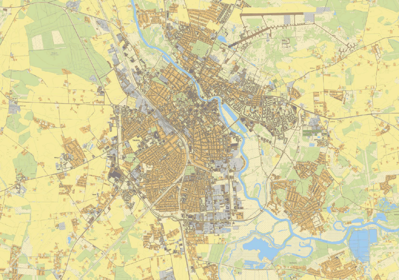
Fragment of the 2025 Estonian base map. The base map is produced once a year in the first quarter, based on ETAK data.
Source: Unless otherwise indicated, the source of the historical content used in this article is the Land Board's online publication "Estonia on the map" (2019, compiled by Irja-Gea Kukk).
Author: Nele Jäetma, Chief Specialist, Land and Spatial Development Board, Map Data Department
Loomise kuupäev: 13.11.2025
